


The decennial census plays an essential role in American democracy. Our series of blog posts examines what’s at stake for California and the challenges facing the 2020 Census, including communities that are at risk of being undercounted.
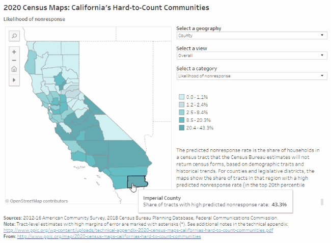
PPIC’s interactive census maps are an important tool for Californians working to ensure an accurate census count. Using estimates from the Census Bureau and the Federal Communications Commission, they highlight hard-to-count communities across the state and pinpoint reasons why certain areas may be hard to reach.
Home to nearly 200,000 people, Imperial County will likely be one of the hardest-to-count counties in California. According to Census Bureau estimates that draw on demographic characteristics (e.g., race/ethnicity, age, citizenship, and housing conditions) and historical trends, 43% of census tracts in the county will be very hard to count—the highest percentage of any county in the state. Households in these very hard-to-count areas—which are concentrated in the western half of the county, around the Salton Sea and El Centro—are the least likely to respond initially to census forms and are therefore at risk of being undercounted.
Some highlights:
- Legislative districts representing Imperial County are among the hardest to count in California. Between 33% and 52% of census tracts are considered very hard to count in Congressional District 51 (Vargas), State Senate District 40 (Hueso), and State Assembly District 56 (Garcia). Undercounting residents of these districts could result in political representation shifting away from Imperial County and toward areas with higher population counts, since district lines will be redrawn based on the results of the 2020 Census.
- Almost all residents belong to demographic groups that have been historically undercounted. In the past, the census has disproportionately undercounted African Americans, Latinos, and Native Americans, as well as young children. The large majority of Imperial County’s population is Latino—with higher shares of Latinos in the western half of the county—and the Fort Yuma Indian Reservation is located in the southeast. Altogether, 86% of county residents are African American, Latino, or Native American (compared to 45% statewide). Noncitizens—who may be less likely to respond in 2020 due to the planned addition of a citizenship question and concerns about deportation and privacy—make up 17% of residents in this border county (compared to 14% statewide).
- Imperial County has a high share of young children, particularly in its cities and towns. Children under five years old make up 8% of Imperial County residents, compared with 6.5% statewide. Most young children live in the Imperial Valley, along the corridor from the Salton Sea to Calexico, or outside Yuma, Arizona. In the more rural areas to the east and west, less than 3% of county residents are children under five.
- Housing conditions could make it difficult to accurately count residents. Compared to the rest of the state, Imperial County has relatively high shares of renters (44%), overcrowded rental units (15%), and mobile homes (8%), all of which can make residents harder to count. Reaching residents at home will require strategies that vary by geography and reflect local understanding of how families make ends meet. In the eastern part of the county, for example, almost 60% of housing units are mobile homes, and about 20% are rentals, while in and around El Centro and Calexico less than 20% of units are mobile homes but more than 60% are rentals.
- Much of the county lacks high-speed residential internet access. The Census Bureau plans to collect the majority of responses online in 2020—a change from previous practice. Imperial County has one of the lowest rates of internet access in the state: with the exception of only one neighborhood in El Centro, fewer than 800 households per thousand in the county have high-speed internet connections. In places with limited residential internet access, census participation may rely more heavily on paper forms, in-person census takers, or internet provided by local institutions.
We hope these maps serve as a starting point to help local, regional, and state leaders think about which activities, resources, and partnerships—including language assistance, awareness raising, and community outreach—might be most effective for accurately counting different parts of California. While this concludes our regional series on hard-to-count communities throughout the state, stay tuned for future posts on the decennial census as we near 2020.